Travels
Getting to the convention and returning home the convention is usually a quick trip by car, train or plane. Sometimes we even use a combination of these transportation modes. For this convention most if not all of the attendees will be using personal vehicles for the final leg of this trip. To help make it more interesting, Northern Ontario is beautiful, the convention committee has Road Logs and Transportation Trips that increase the overall wow factor. Take time and have a look.
Travel by Air
Thunder Bay is served by multiple daily flights by Air Canada, Porter Airlines and Westjet, mostly from Toronto but also from Winnipeg. With advance booking and traveling in off peak time return fares including taxes have be found as low as $260 per person. These types of fares have been reported to the Organizing Committee by delegates.
Travel by Road
Road Log East
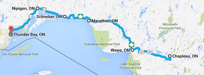
| Routes: | Highway 101 from Chapleau to Wawa via Hawk Junction and Highway 17 (Trans Canada Highway "TCH") from Wawa to Thunder Bay |
| Notes: | On the TCH there are Km posts every 2 kms which count down to zero on the Ontario-Manitoba border. These are used as references for distances on the TCH. However they are not complete, with long sections from Nipigon to Thunder Bay missing any signs. Therefore correlate your car odometer with the first kilometre sign you see so that you can then recalculate your road log to match your odometer. The TCH from Nipigon to Thunder Bay is being rebuilt as a 4 lane divided highway. On weekdays expect delays and flagmen holding up traffic where only one lane is available. They are also rebuilding the road bridge over the Little Pic River on the TCH (Highway 17) between Marathon and Terrace Bay (see Km 810.5) and there may be delays with one lane traffic flow alternating. |
| Location | Hwy | Kms | Features |
|---|---|---|---|
| Chapleau town centre, CP station | Off 101 | 129 kms E of Wawa | Static display of CP5433, a CLC 2-8-2, Class P2h and caboose 434627 plus various speeders and MOW equipment. |
| Chapleau town centre pedestrian overpass over CP tracks | Off 101 | 129 kms E of Wawa | Excellent views of CP Chapleau yard, loco tracks, turntable, station and double track main tracks. Chapleau is a crew change point and loco fueling depot so all mainline trans Canada trains stop here for at least 20 minutes. |
| Hawk Junction | Off 101 | 19 kms E of Wawa | CN - Algoma Central station, yard and former junction with iron ore mine and Michipicoten Harbour Sub. One to two trains per day come through here including one passenger train most days. |
| Between Wawa and White River | 17 | 941 | Overpass carries TCH over CP tracks which display a tight S bend. NOTE NO CONVENIENT PARKING AROUND HERE AND NO PEDESTRIAN WALKWAY ON BRIDGE. |
| Between Wawa and White River | 17 | 939.5 | Pull off at picnic spot with toilets at Depew River bridge where CP bridge is nicely visible as a two part structure with centre span a steel beam flanked on east side by a masonry arch. Good, safe parking. |
| White River | 17 | 929 | At junction of side road to town centre is rest area with reconstructed CP station, section of track, CP caboose 437136 and CP Fairmont speeder. Also close to here is statue of Pooh Bear as White River is the home of the history of the Winnie the Pooh books. |
The last 20 - 30 kms of Hwy 17 to Thunder Bay are mostly opened as a new freeway now. The freeway follows a bypass route that largely goes around the perimter of Thunder Bay, therefore when you reach the first exit (on a hill top in a rock cut just beyond the Terry Fox Memorial exit) take the exit ramp on the right and then turn left and cross over the freeway and follow the road downhill into town and towards the lake. The road is called Hodder Avenue and then changes its name to Cumberland St when it turns right and parallels the drydock, grain elevators and railway tracks. Follow along Cumberland for several kilometres and then immediately past traffic lights with River Street, Cumberland takes a right hand exit lane while the continuing road changes name again to Water Street. Go along the diverging Cumberland St and after about five blocks the Prince Arthur Hotel is the large building on the left hand side.
This is just a sample of the log. Use the above link to download all 9 pages with accompaning images.
Road Log West
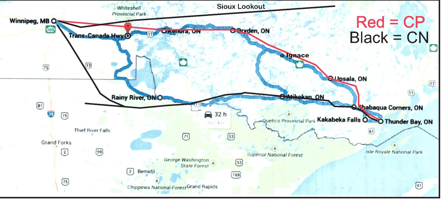
| Routes: | Trans Canada Highway in Manitoba from Winnipeg to Ontario border Highway 17 (Trans Canada Highway "TCH") from Manitoba border to Thunder Bay Alternative Highway 11 via Atikokan to Shabaqua Corners Alternative Highway 102 from Hwy 11/17 east of Shabaqua Corners to Thunder Bay |
| Notes: | On some portions of the TCH in Ontario there are Km posts every 2 kms which count down to zero on the Ontario-Manitoba border. Where these exist they are used as references for distances on the TCH. Where such signs do not exist we have described features by the best available means, usually distance from a prominent feature like a highway junction. Therefore correlate your car odometer from whatever starting feature we have used so that you can then recalculate your road log to match your odometer. At the time of writing this road log we were unaware of any major road construction on the described routes. |
| Location | Hwy | Kms | Features |
|---|---|---|---|
| Path 1: Trans Canada Highway in Manitoba from Winnipeg to Ontario border | |||
| TCH Winnipeg to the Ontario border | TCH 1 | 0 - 142 Kms Wpg - ON border | Both CN and CP main lines are well north of the TCH in this portion of Manitoba and there is little RR related to see without making a deviation northwards. One reccommended deviation is to go north on Hwy 11 (82 kms from Wpg), cross the CN tracks, then turn east at Km 32 onto Hwy 44 which parallels the CP tracks to the point close to the road where the CN crosses the CP on an overpass just west of Rennie. Continuing east on Hwy 44 beside the CP line allows one to rejoin the TCH via West Hawk |
| Path 2: Highway 17 (Trans Canada Highway "TCH") from Manitoba border to Thunder Bay | |||
| TCH Ontario border to Shabaqua Corners | Hwy 17 | Wpg - T Bay is 685 Kms | This whole length of Hwy is never far from the CP mainline except where the road has been rerouted such as the bypass north of Kenora. The CP mainline used to be double track all the way from Thunder Bay to Winnipeg but with the advent of CTC the second tracked was ripped out but the extra wide grade and many double width bridges still exist along the Right of Way. Now it is only double track for the last 50 or so kilometres into Thunder Bay. |
| Hwy 17 | Approx 42 kms from MB border | When approaching Kenora take the old road that runs right through the town and stop at the railroad museum on the south side of the main street. There are a restored CP SW1200RS locomotive (CP 8120) and a CP caboose (CP 437473). Specific address is at intersection of Parson Street and Lakeview Drive, next to the Dairy Queen. | |
| Hwy 17 | Approx 20 kms east of Kenora | The CP main line crosses over Hwy 17 on an overpass with the highway taking an S bend to pass under the tracks. Just beyond the overpass are a layby area on the highway. | |
| Hwy 17 | 203 Kms from MB border | Dryden, which has a large paper mill with a long CP yard and usually lots of box car switching activity. Also has a restored CP caboose (CP 434424) on static display adjacent to the main road. The CP tracks and yard are parallel to and beside the road through the east half of Dryden. | |
ADDITIONAL RAILFANNING INFORMATION FOR THE IMMEDIATE THUNDER BAY AREA WILL BE AVAILABLE IN SEPARATE DOCUMENTS HANDED OUT AT CONVENTION REGISTRATION.
This is just a sample of the log. Use the above link to download all 7 pages with accompaning images.
Travel by Train
Train schedules
Schedules are based on Fall 2013 information and will most likely be unchanged for 2014. VIA schedules will be valid for Fall 2014.
To Thunder Bay area via VIA: VIA Rail Website
| Arrive | From East: | From West: |
|---|---|---|
| Toronto | Sat. 27/9 dep. 22:00 | |
| Armstrong | Sun. 28/9 21:31 | Fri. 26/9 or Mon. 29/9 09:48 |
| Sioux Lookout | Sun. 28/9 23:40 | Fri.26/9 or Mon. 29/9 05:02 |
| Winnipeg | Mon.29/9 08:00 | Thur. 25/9 or Sun. 28/9 20:45 |
| Depart | To East: | To West: |
| Armstrong | Fri. 03/10 09:48 | Fri. 03/10 21:31 |
| Sioux Lookout | Fri. 03/10 05:42 | Sat.04/10 00:09 |
| Note: Armstrong is not a regular stop and has no car rental facilities and little or no accommodations. For Armstrong and Sioux Lookout, a means of transport of several hours is needed to get to Thunder Bay and because of some arrival times, an overnight stay might be necessary upon arrival at these stations. | ||
Transportation Trips
In addition to travel to the convention by VIA, there are train excursions that might be of interest to those travelling to the convention by automobile: The Agawa Canyon Tour train with a view of the fall foliage, and the Sudbury to White River RDC (“Budd car”) trip which has been described by Trains Magazine as one of the “must do” tours to take while it still exists. Here are some schedules to consider:
| Sudbury-White River RDC: VIA Rail Website | |
|---|---|
| Dep. Sudbury: Tu., Th,. Sat. 09:00 | Arr. White River 17:45 |
| Dep. White River: Wed.,Fri., Sun. 09:00 | Arr. Sudbury 18:30 |
| Agawa Canyon Tour Train: Agawa Canyon Website | |
| Daily, Dep. Sault Ste. Marie 08:00 | return 18:00 |